Posts

Showing posts from 2018

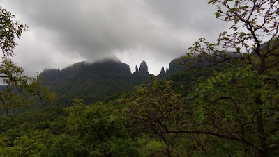
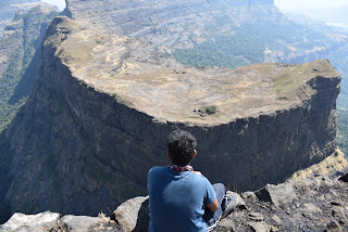
SANDHAN VALLEY - WHERE ROUTES ARE A MYTH

Image
Me, madly lost in the beauty of Sahyadri!  Sandhan valley! The place which I have been fantasizing about for last 3 years! For last 3 years, I've been binge watching the photos of Sandhan valley and dreaming about how cool it would be if I ever go there. It was like a dream come true to go there and return with a suitcase of memories with your GANG! Sandhan valley, deepest valley in Sahyadris, which stands 2nd in the deepest valleys of Asia; is a perfect example of beauty and the beast! The valley is so beautiful and breathtaking yet it is so dangerous and fatal. The depth of the valley is just 200 ft, yet it never fails to depict the beauty of sahyadri boldly! Surrounded by the mighty Ratangad, Kalsubai peak, Alang Madan and Kulang, this "valley of shadows" is nothing but an all in one package for every fellow trek mate. Sandhan valley is located in Ahmednagar district, Maharashtra. To get there, we can go via Samrad village which is nearest to the valley. Sa

सांधण दरी (सांधण व्हॅली)

Image
सह्याद्री च्या प्रेमात असलेला मी. गेल्या ३ वर्षांपासून ज्या जागेचे फोटोज बघून "यार किती सुंदर जागा आहे, इकडे आयुष्यात एकदा तरी जाणार"   ही वाक्य बाहेर पडायची, तिकडे जाऊन, तिथुन असंख्य आठवणींची शिदोरी घेऊन परत येणं याला "स्वप्नपूर्ति" असं म्हटले तर त्यात काही नवल नाही.  सांधण व्हॅली ! सह्याद्री मधली एक खोल दरी, आशिया खंडातील क्रमांक दोनची खोल दरी.अत्यंत सुंदर आणि तितकीच भयाण. सांधण व्हॅली ची खोली फक्त २०० फूट असली, तरीही त्या २०० फूट मध्ये सह्याद्रीचं  सौंदर्य ठळकपणे दिसतं ! रतनगड, कळसुबाई शिखर, अलंग मदन कुलंग यांनी वेढा दिलेली अशी ही "valley  of shadows"   म्हणजे   प्रत्येक गिर्यारोहकासाठी अगदी ऑल इन वन पॅकेजच ! नाशिक जवळील भंडारदरा येथील सामरद गावातून सांधण व्हॅली मध्ये जाता येते. सामरदला पोहोचण्यासाठी आम्ही रात्री कसारा ची ट्रेन पकडली. रात्री १.३० वाजता कसाऱ्याला पोहोचलो. यावेळेस चा ट्रेक हा drifters सोबत चा होता, आणि त्यांच्या सोबत मी आधीच अलंग-मदन-कुलंग केल्याने मी काही नवखा नव्हतो. उलट सगळे जुने मित्र जसे भेटले, तशी ट्रेक ची उत्सुकता १००

HARIHAR

Image
Harihar from Nirgudpada I remember it very clearly, two years ago, that is, in April 2016 where all this trekking thing began all over again in my life, Harihar was the trek which we were planning to complete as a kick start to our trekking life. But eventually, we ended up doing Lohagad; and the rest is history. So basically, Harihar was a 2 year long awaited dream trek for all of us! Harihar is situated in Nasik district and is one of the main attraction in Sahyadri's! We can go up there via 2 routes. First is Harshewadi , and other is Nirgudpada . We chose the Nirgudpada route. To reach there, there are following modes of transport available: 1) Private : Nirgudpada is 113 km away from Mumbai. So you can drive there and park your vehicle anywhere in the village. 2) Local : First take the train to Kasara, and from there local vehicles are available to get to Nirgudpada. The vehicle can accommodate 10 people easily. One vehicle costs Rs.3000/- for a return journey. I

MAHULI - HIGHEST PEAK OF THANE

Image
Mahuli from Asangaon So after semester 2 exam, and a lot of medical emergencies in my family, Mahuli was officially the first trek of the season for me, and eventually the very first trek as an organizer. Being an organizer, I learnt many new things about commercial trekking, which I never thought I'll do in my life. Till now, I've been on treks with my friends, where we don't really give a shit about who's leading and who's behind. But this time, everything had to be planned. Before going for the actual trek, I read some blogs by other people. And among 2/3 blogs I read about mahuli, all were negative. Each and every blog I read said that "I couldn't complete Mahuli because of some reason." I was really tensed because this time I had a responsibility of 25 people. But climate played its role perfectly. Mahuli is the highest peak in Thane district. Asangaon is the nearest railway station to the fort. One can reach there by following modes of

GHODBUNDER FORT

Image
Gate and Watch Tower So after one full month of frustration and exams, I'm here with a whole new blog with a location that hardly few people know about. Me and my friends came to know about this place through google. We were bored to go to usual places where most of the "cool" crowd hangs out, like 1) Marine lines, Mumbai 2) Bandra Reclamation 3) Gaimukh (More like cheap thrills of marine lines)  4) Hiranandani (Any of it! Except the fact that we only visited Powai) So this time , we came up with something new. We searched google and found out this, "Ghodbunder Fort" . West side of fort Ghodbunder fort is located in Ghodbunder village, near Mira-Bhayandar express highway. It is approximately 23 km from Thane railway station. It was built by Portuguese, which was later occupied by Maratha Empire and then it became the East India Company's district headquarters. The place is called Ghodbunder because Portuguese used to trade Horses

LAVASA : PERFECT WEEKEND TRIP

Image
So after almost 4 months of busy schedule, I finally decided to gift myself with a short holiday trip. College was over and exams are coming, so this was the best time for me to take a short break from routine. This time, I went to Lavasa with my parents. LAVASA CITY FROM NATURE TRAILS BY "EKAANT" Lavasa is a planned city which is still under construction near Pune. It is stylistically based on the Italian town Portofino.  In 2010, The Indian Environment and Forests Ministry ordered a cease on construction, as this project violated environmental laws; but in late 2011, the cease was cancelled. The area that is marked as Lavasa City is the 'Mulshy Valley' of the Western Ghats.  (Source: Wikipedia) So, the journey started. We boarded the "Thane-Pune-Thane Shivneri Bus" of MSRTC. To be honest, I was happy, not because I was visiting Lavasa for the first time, but because I was travelling to Pune. There are only 2 locations which suit the phrase "

ALANG-MADAN-KULANG:- TOUGHEST TREK OF MAHARASHTRA

Image
Alang fort from Madan So after a lot of planning, discussions, & research we decided to go for the toughest trek of Maharashtra; the Alang-Madan-Kulang trek! Alang_Madan-Kulang are 3 different forts which are joined by small routes and all three forts are difficult to hike. If you're hiking somewhere else in Sahyadri's and see the route is no longer leading anywhere, I would say you should turn back and look for another route. But here, at AMK, if you see the road is blocked due to some landslide or huge chunks of rocks and see the route is no longer leading anywhere; it won't be a great suggestion to turn back and look for another route. At AMK, you have to cross those chunks somehow and go ahead. The route is very much exposed to deep valleys and the width of route is very short; i.e only 1 person can walk at a time. View from Alang These forts are not historically significant. What makes them special is they are very difficult to climb. During the reig